
Lost structure, Lafayette Park, 1930 to 2008
Antietam Avenue Bridge
Demolished in 2008
- Opened
- 1930
- Torn down
- 2008
The Antietam Avenue Bridge stood in Lafayette Park from 1930 until 2008. Here is what it was, who made it and where to find the spot today.
Then and now
What stands there now


Dequindre Cut Greenway
Detroit's Antietam Avenue Bridge stood on this spot for 78 years. It came down 18 years ago. Today the spot is part of Dequindre Cut Greenway.
- 1930 Opens Antietam Avenue Bridge
- 2008 Comes down Antietam Avenue Bridge
- 2026 Today Park
How we know what stands there
- OpenStreetMap Dequindre Cut Greenway, park at the map point
Checked October 25, 2026. We never guess: a site no source speaks for shows no answer.
What is there now
Dequindre Cut Greenway
- Today Park Source: OpenStreetMap
- Antietam Avenue Bridge came down Source: National Register of Historic Places
We checked Wikidata, Wikipedia, OpenStreetMap, Rebuild Detroit's landmark records and the county parcel records on October 25, 2026.
The story
The Antietam Avenue Bridge went up in 1930, as Detroit pushed through the Depression.
The National Register of Historic Places listed it in 2000.
It is gone now, demolished in 2008, and the map pin below marks where it stood.
The Antietam Avenue Bridge was located where Antietam Avenue passed over the Dequindre Cut (formerly owned by the Grand Trunk Western Railroad) in Detroit, Michigan. It has been demolished due to structural deficiencies and will be reconstructed. The original bridge was listed on the National Register of Historic Places in 2000.
Timeline
- 1930 Built
- 2000 Listed on the National Register February 18, 2000
- 2008 Demolished
- 2026 Today 18 years since it came down
Where it is
Antietam St. over the Grand Trunk Railroad line
On this map
- 1 Antietam Avenue Bridge This place
- 2 St. Joseph's Roman Catholic Church 230 ft
- 3 Saint Joseph Roman Catholic Parish Complex (Boundary Increase) 240 ft
- 4 Chestnut Street-Grand Trunk Railroad 250 ft
- 5 St. Joseph Shrine 270 ft
- 6 Koenig Coal & Supply Co. Building 0.1 mi
- 7 Wisner Confectionary Building 0.2 mi
- 8 St. John's-St. Luke's Evangelical Church 0.2 mi
- 9 Frontera & Son 0.2 mi
Street map from OpenStreetMap contributors
More from Detroit in the 1930s
-
 Brodhead Naval Armory
Building, built 1930, Art Deco/Art Moderne, by Stratton & Hyde
Photo: Andrew Jameson, CC BY-SA 3.0, via Wikimedia Commons
-
 Denby High School
School, built 1930, Art Deco, by Smith, Hinchman & Grylls
Photo: Andrew Jameson, CC BY-SA 3.0, via Wikimedia Commons
-
 Ambassador Bridge
Structure, built 1929, by Jonathan Jones
Photo: Antony-22, CC BY-SA 4.0, via Wikimedia Commons
-
 David Stott Building
Skyscraper, built 1929, Art Deco, by John Donaldson
Photo: Einar Einarsson Kvara aka Carptrash, CC BY-SA 3.0, via Wikimedia Commons
-
 Cooley High School
School, built 1928, Mediterranean Revival, by Donaldson & Meier, demolished 2026
Photo: Chuckjav, CC BY 3.0, via Wikimedia Commons
-
 Broderick Tower
Structure, built 1927, Beaux Arts, by Louis Kamper
Photo: St8fan, CC BY-SA 4.0, via Wikimedia Commons
Around the block
It is in Lafayette Park. See the neighborhood's homes, pros and story.
-
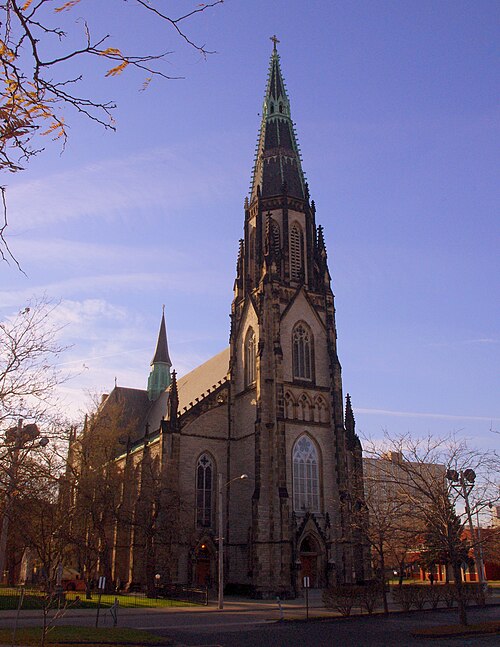 St. Joseph's Roman Catholic Church
House of worship, built 1870, Late Gothic Revival, by Donaldson & Meier
Photo: Nheyob, CC BY-SA 3.0, via Wikimedia Commons
230 ft
- Saint Joseph Roman Catholic Parish Complex (Boundary Increase) Building 240 ft
-
 Chestnut Street-Grand Trunk Railroad
Structure, built 1929, by Grand Trunk Western Railroad
Photo: Andrew Jameson, CC BY-SA 3.0, via Wikimedia Commons
250 ft
- St. Joseph Shrine House of worship, built 1873, Gothic Revival, by Francis Himpler 270 ft
- Koenig Coal & Supply Co. Building Building, built 1911, Art Deco 0.1 mi
- Wisner Confectionary Building Building, built 1931, Art Deco, by H. Lawrence Levander 0.2 mi
-
 St. John's-St. Luke's Evangelical Church
House of worship, built 1872, Late Victorian
Photo: Andrew Jameson at en.wikipedia, CC BY-SA 3.0, via Wikimedia Commons
0.2 mi
- Frontera & Son Building, built 1900, demolished 0.2 mi
Photo credits
Every photo on this page is used under its license, named here with its author and a link to the original.
- Site of Antietam St Bridge over old Grand Trunk Railroad tracks, Detroit MI Photo: Andrew Jameson, CC BY-SA 3.0, via Wikimedia Commons
Sources
Facts only, gathered from these sources. The story above is written by Rebuild Detroit. Every photo names its author and license where it appears.